On October 30, 2025, the world turned its attention to the Caribbean as a catastrophic weather event unfolded. Hurricane Melissa, the most powerful tropical cyclone of the year, unleashed its full fury upon Jamaica and neighboring islands, leaving behind an almost unimaginable trail of destruction. Official reports and high-resolution satellite imagery paint a sobering portrait of devastation: the once-vibrant island nation now bears the scars of winds, floods, and surging seas that reshaped its landscapes and crippled its infrastructure.
When Hurricane Melissa made landfall on Tuesday, it struck Jamaica with extraordinary ferocity. The storm’s sustained winds reached a staggering 185 miles per hour—among the highest ever recorded in the region—turning trees, vehicles, and even entire buildings into airborne debris. Within hours, much of the island’s power grid had collapsed, plunging more than half a million residents into darkness. This catastrophic impact extended beyond Jamaica’s borders, ravaging parts of Cuba, the Dominican Republic, and Haiti, where communities found themselves inundated with floodwaters and cut off from emergency services. Regional authorities have since confirmed that at least thirty lives were tragically lost to the hurricane’s overwhelming force.
In the immediate aftermath, Jamaica’s Prime Minister, Andrew Holness, proclaimed the entire nation a disaster area, marking an urgent step toward coordinating relief efforts and international assistance. Local officials described the situation in blunt, emotional terms—Transportation Minister Daryl Vaz characterized the magnitude of the damage as “enormous,” reflecting widespread loss of homes, businesses, and historic sites that had helped define Jamaica’s cultural identity. Early economic assessments from AccuWeather estimated total damages and financial losses could reach between $48 billion and $52 billion, a staggering sum that underscores both the scale of the disaster and the immense challenge of recovery that lies ahead.
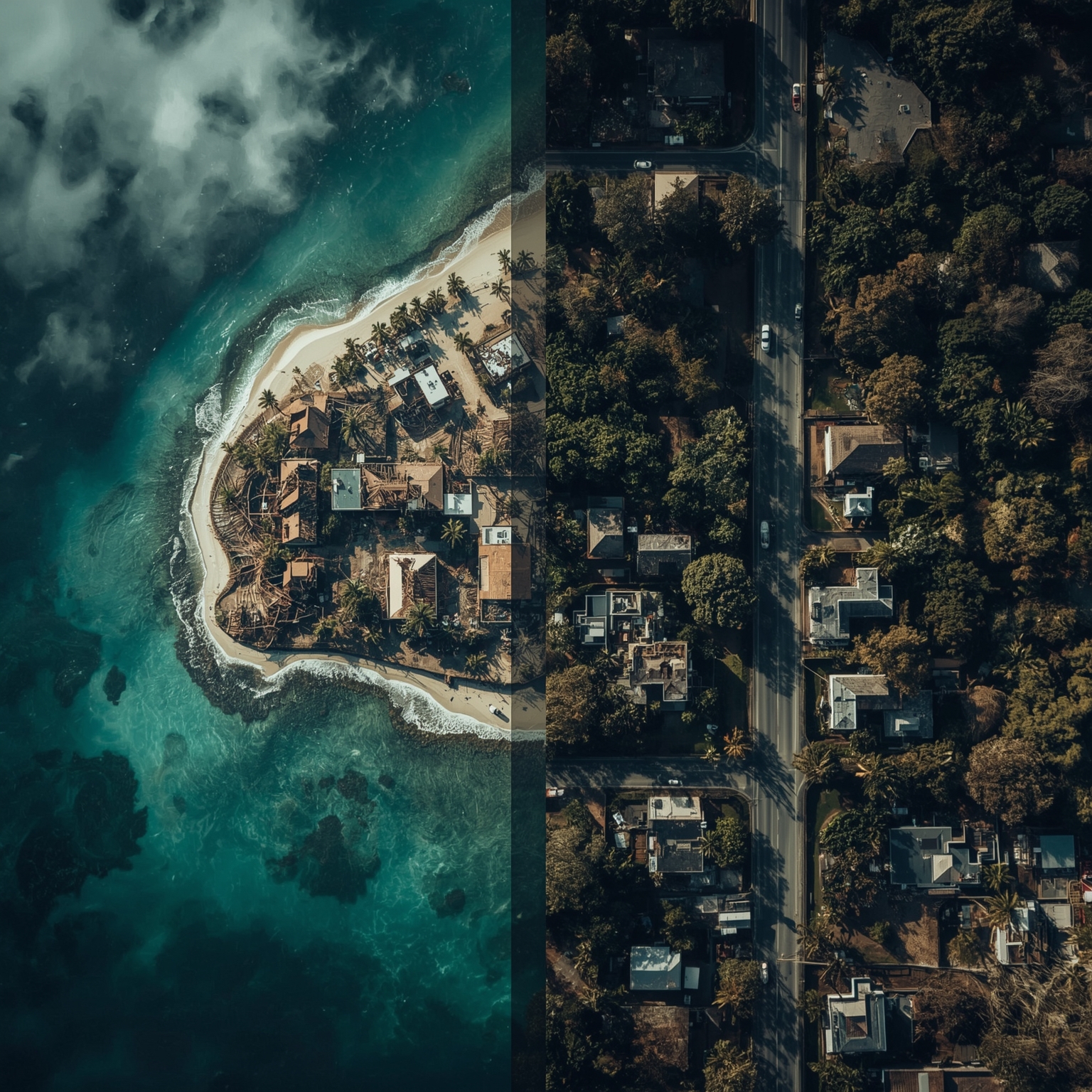
Satellite data provided by the U.S.-based spatial intelligence firm Vantor vividly documents the hurricane’s sweeping consequences. By comparing pre- and post-storm imagery, observers can fully grasp the transformation of Jamaica’s coastal communities. For instance, in the seaside town of Black River—home to roughly four thousand residents and known for its centuries-old architecture—the new images reveal a heartbreaking contrast. Many of the town’s treasured landmarks, including a three-hundred-year-old church that had stood as a testament to Jamaica’s colonial past, were completely obliterated. Prime Minister Holness later referred to Black River as “Ground Zero,” emphasizing its role as one of the hardest-hit localities in the country. Close-up imagery captures streets buried under debris, tangled remnants of rooftops, and the skeletal framework of structures that once bustled with life and commerce.
To the southwest, the community of White House, also populated by about four thousand people, experienced a similar fate. Before Melissa, its shoreline was lined with modest beachfront properties and small tourism enterprises. After the storm, satellite views expose a coastline stripped bare—beachfront buildings have vanished, their foundations swept into the ocean. Only fragments of docks and scattered debris remain as bleak reminders of what once was.
The northern city of Montego Bay, celebrated internationally for its crystal-clear waters and bustling resorts, now tells a different story. Satellite photographs reveal a drastic shift in its appearance: the brilliant turquoise hues of the bay have turned into muddy brown swirls, the result of severe sediment displacement and coastal contamination. Streets that once hosted holidaymakers are now submerged under layers of debris and floodwater, their familiar vibrancy replaced with silence and ruin.
Another area grievously affected is New Hope, a community that found itself entirely encompassed by the storm’s surging tides. Storm surges there reached up to thirteen feet, engulfing homes, agricultural land, and infrastructure. The comparative images from Vantor depict neighborhoods that appear almost erased from view, completely submerged under opaque floodwaters.
Across the entire region, the statistics remain sobering: more than half a million individuals were left without access to electricity or clean water, while at least thirty confirmed fatalities speak to the severe human toll. As emergency crews restore communication lines and clear roadways, the enormity of the reconstruction effort becomes increasingly clear. The physical and psychological scars left by Hurricane Melissa will not fade quickly.
For Jamaica, and indeed the greater Caribbean community, this storm represents not only a natural disaster but also a test of resilience. Recovery will demand unprecedented cooperation between the government, local residents, and international partners. The newly captured satellite images serve not merely as tools for assessment but as enduring records of a moment in history when nature’s power overwhelmed human preparation. They remind us that the effects of this calamity will resonate for years—shaping the country’s economy, environment, and collective memory long after the skies have cleared.
Sourse: https://www.businessinsider.com/hurricane-melissa-satellite-images-before-and-after-jamaica-2025-10